


Layers and Groups Tab #
Please refer to the following guide for all settings https://qgis2web.github.io/qgis2web/#LayersandGroups
Advanced popup #
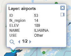
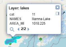
qgis2o.gis integrates a popup that highlights the selected feature and allows you to browse the overlapping features.
This advanced popup supports the various options described above.
| First feature | Second feature |
 |  |
By default #
- the tab shows the list of layers present in the QGIS project, but the export check will only be present in the QGIS layers turned on before starting the plugin
- the layers do not have the “Visible” check, therefore when the exported project is started they will not be immediately visible on the map
- Popups always has the check active so it will be possible to query the layers in the exported project (to hide fields from the query popup set Hidden as explained here)
- Popup fields is set to “no label” because it is the most used
Appareance Tab #
Match project CRS #
Create webmap in same projection as QGIS project, otherwise the webmap is projected in EPSG:3857
Show popups on hover #
Show popups when mouse hovers over features
Highlight on hover #
Highlight features on mouseover
Template #
A default template is provided, you can add others as you like.
Extent #
Default zoom level when starting the exported project. Canvas extent either match the current QGIS.
Restrict to extent #
Prevent panning or zooming beyond the selected extent and reduces the size of the exported project by not including geometries outside the selected extent.
Max zoom level #
How far the webmap will zoom in
Min zoom level #
How far the webmap will zoom out
Export Tab #
Please refer to the following guide for all settings https://qgis2web.github.io/qgis2web/#Export